Trail Walking Langnau im Emmental - hike28 - Photo

Optez pour le retour à la nature GUIDE+
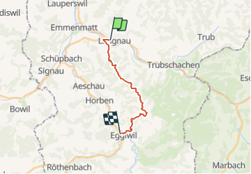
© OpenStreetMap contributors
Length
Length
12.3 km
Max alt
Max alt
1151 m
Uphill gradient
Uphill gradient
628 m
Km-Effort
Km-Effort  
20 km
Min alt
Min alt
668 m
Downhill gradient
Downhill gradient
565 m
Boucle
Boucle
No
Creation date :
2014-12-10 00:00:00.0
Updated on :
2014-12-10 00:00:00.0

(0 Reviews)

Walking
Walking
--
Difficulty : Unknown

Scan this QR Code to open this trail in the SityTrail application

FREE GPS app for hiking

Logo SityTrail SityTrail

IGN / Geographical institutes

Download SityTrail from the App Store Download SityTrail from Google Play

Logo SityTrail SityTrail Plus

The world is yours!

Download SityTrail from the App Store Download SityTrail from Google Play Download SityTrail on Huawei AppGallery

About

Trail Walking of 12.3 km to be discovered at Bern, Emmental administrative district, Langnau im Emmental. This trail is proposed by My Switzerland.

Elevation profile

Points of interest

Point of interest Langnau im Emmental - Langnau i.E. - Photo
My Switzerland
LANGNAU IM EMMENTAL 
Point of interest Langnau im Emmental -  - Photo
My Switzerland
LANGNAU IM EMMENTAL 
Point of interest Trubschachen -  - Photo
My Switzerland
TRUBSCHACHEN 
Point of interest Eggiwil - Eggiwil - Photo
My Switzerland
EGGIWIL 

Positioning

Country:
Switzerland
Region :
Bern
Department/Province :
Emmental administrative district
Municipality :
Langnau im Emmental
Location:
Unknown
Start:(UTM)
407477 ; 5199149 (32T) N.


Close
My subscriptions